Riviera Maya: Caribbean Beaches, Cenotes & Chichen Itza Day Trips
The Riviera Maya is a coastal tourism region stretching approximately 160 kilometers (100 miles) along Mexico's Caribbean shore, from Cancun in the north to Tulum in the south. Located in the state of Quintana Roo on the eastern edge of the Yucatan Peninsula, it is one of the most visited travel regions in Latin America.
The Riviera Maya encompasses beach towns, all-inclusive resorts, ancient Maya archaeological sites, thousands of cenotes, eco-parks, and one of the world's largest coral reef systems. Its diversity—from Caribbean beaches to jungle-covered ruins—makes it a region where travelers can combine relaxation, culture, and adventure in a single trip.
Beyond the coastline, the Riviera Maya serves as a gateway to the Yucatan interior. Day trips to Chichen Itza, Valladolid, and inland cenotes are among the most popular excursions for visitors staying anywhere along the coast.
Quick Facts: Riviera Maya
| Location | Quintana Roo, eastern Yucatan Peninsula, Mexico |
| Coastline | 160 km Caribbean coast — Cancun to Tulum |
| Main towns | Cancun, Puerto Morelos, Playa del Carmen, Akumal, Tulum |
| Airport | Cancun International (CUN) — serves entire corridor |
| Known for | Caribbean beaches, cenotes, Maya ruins, coral reef, eco-parks |
| Average temperature | 26–33°C (79–91°F) year-round |
| To Chichen Itza from Cancun | ~197 km — about 2 hours 18 minutes by car |
| To Chichen Itza from Playa del Carmen | ~182 km — about 2 hours 9 minutes by car |
| To Chichen Itza from Tulum | ~153 km — about 2 hours 3 minutes by car |
| Time zone | Eastern Standard Time (EST) |
| Best time to visit | December–April (dry season) |
What the Riviera Maya Actually Is (And Why Travelers Keep Coming Back)
Few travel regions in the world offer the Riviera Maya's combination of Caribbean beaches, ancient history, and natural wonders within such a compact corridor. The region consistently ranks among the top destinations in the Americas for both leisure and cultural travel.
- Over 160 km of white-sand Caribbean coastline with warm, swimmable water year-round
- Thousands of cenotes—freshwater sinkholes unique to the Yucatan limestone platform
- Ancient Maya archaeological sites including Tulum, Coba, and access to Chichen Itza
- Part of the Mesoamerican Barrier Reef, the second-largest coral reef system in the world
- Eco-parks, biosphere reserves, and wildlife sanctuaries throughout the corridor
- Major international airport (CUN) with direct flights from North America, Europe, and South America
Overview of the Riviera Maya
The Riviera Maya runs along the eastern coast of the Yucatan Peninsula in Quintana Roo, facing the Caribbean Sea. The corridor follows Highway 307, which connects Cancun in the north to Tulum in the south, passing through Puerto Morelos, Playa del Carmen, Akumal, and dozens of smaller communities along the way.
The northern end is anchored by Cancun, the region's largest city and home to the international airport that serves the entire coast. Moving south, the landscape shifts from large-scale resort developments to smaller beach towns, boutique hotels, and eventually the eco-tourism zone around Tulum and the Sian Ka'an Biosphere Reserve.
Inland from the coast, the flat Yucatan jungle stretches westward toward Merida and the archaeological heartland. This combination of coastal recreation and inland cultural depth is what makes the Riviera Maya function as both a beach destination and a base for exploring the wider peninsula.
History and Development of the Riviera Maya
The Caribbean coast of the Yucatan has been inhabited for over a thousand years. The ancient Maya established trading ports along this shore, with Tulum serving as one of the most important coastal commercial centers during the Post-Classic period (1200–1500 CE). Smaller settlements, shrines, and navigation points dotted the coastline between what is now Cancun and Tulum.
Modern development began in the early 1970s, when the Mexican government selected Cancun as the site for a planned international tourism project. The construction of Cancun's Hotel Zone and international airport transformed the region from a sparsely populated coastline into Mexico's most visited destination within two decades.
Through the 1990s and 2000s, tourism expanded southward. Playa del Carmen grew from a small ferry port into a walkable beach town with its own distinct character. Tulum evolved from a backpacker stop into an internationally recognized eco-tourism destination. Resorts, eco-parks, and residential developments filled the corridor between them.
The name "Riviera Maya" was formally adopted in 1999 as a regional tourism brand. Today, the corridor receives tens of millions of visitors annually, supported by one of Latin America's busiest airports and an expanding network of hotels, restaurants, and tour operators.
Major Destinations in the Riviera Maya
The Riviera Maya is not a single city but a collection of distinct destinations along the coast, each with its own character and appeal.
Cancun
Cancun is the region's largest city and the main international gateway. Its Hotel Zone is a 23-kilometer barrier island lined with large resorts, while downtown offers local restaurants, markets, and a more authentic Mexican atmosphere. Cancun's airport (CUN) serves the entire Riviera Maya.
Playa del Carmen
Playa del Carmen sits at the center of the Riviera Maya corridor. Its pedestrian Quinta Avenida (Fifth Avenue) is the social heart of the coast, and ferries to Cozumel depart from its pier. The town offers a more compact, walkable experience than Cancun.
Tulum
Tulum anchors the southern end of the Riviera Maya. Its clifftop Maya ruins overlook the Caribbean, and the surrounding area is known for cenotes, eco-boutique hotels, and the Sian Ka'an Biosphere Reserve. Tulum attracts wellness travelers, history enthusiasts, and nature lovers.
Top Attractions in the Riviera Maya
Maya Archaeological Sites
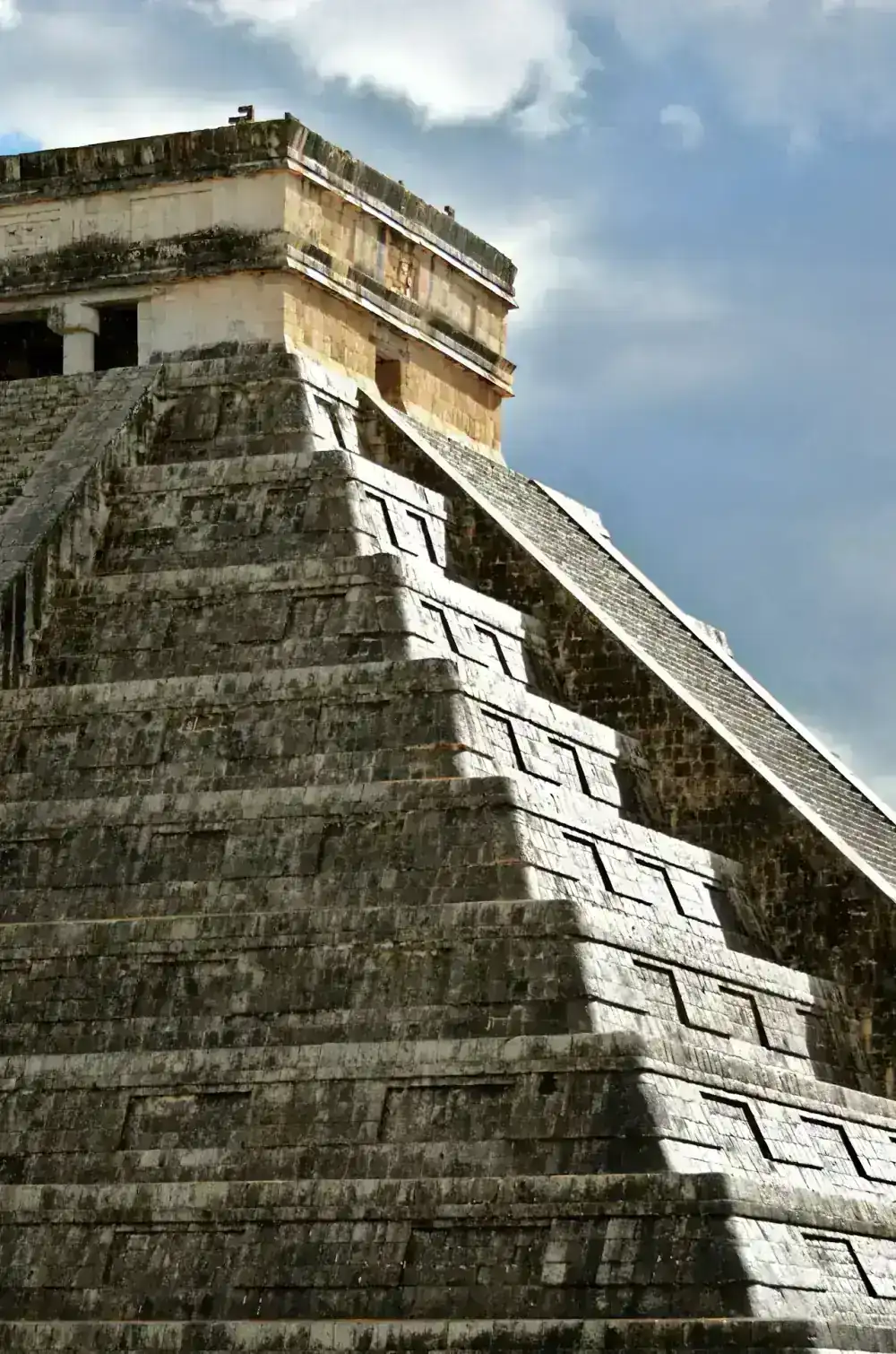
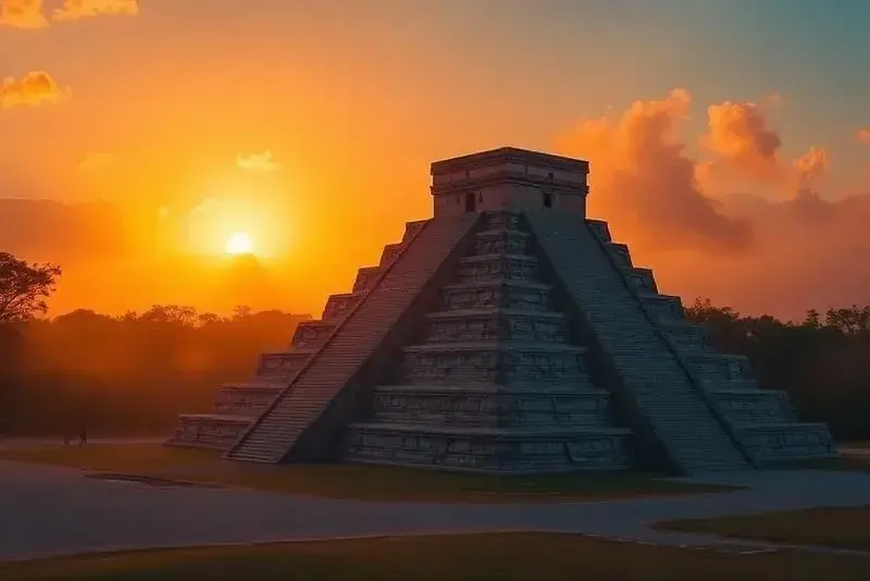
The Tulum ruins are the most visited archaeological site directly on the Riviera Maya coast — the only major Maya city built on a Caribbean cliff. Coba, about 40 km inland from Tulum, features Nohoch Mul — the tallest Maya pyramid structure in the region (climbing reopened December 2025). Further inland, Chichen Itza and Ek Balam are accessible as day trips from anywhere along the coast.
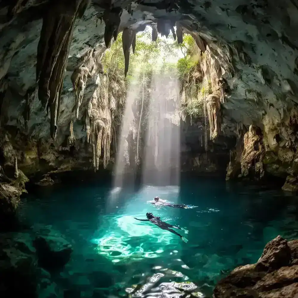
Cenotes
The Yucatan Peninsula contains an estimated 6,000+ cenotes, and the Riviera Maya has some of the most accessible. Browse all cenotes in the Yucatan for a full comparison. Near Tulum, Gran Cenote and Cenote Dos Ojos draw swimmers and divers. Along the inland route to Chichen Itza, Cenote Ik Kil, Cenote Suytun, and Cenote Oxman are popular tour stops.
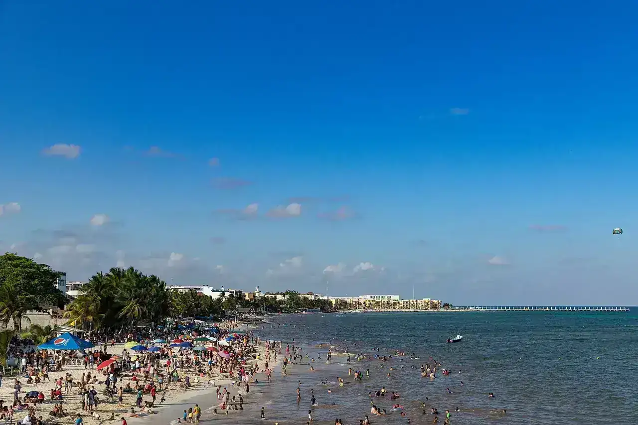
Caribbean Beaches
The Riviera Maya's beaches are characterized by fine white sand and calm, warm Caribbean water. Highlights include Playa Delfines and Playa Chac Mool in Cancun, Playa Mamitas in Playa del Carmen, Akumal Bay (known for sea turtle snorkeling), and Playa Paraíso near the Tulum ruins.
Eco-Parks and Nature Reserves
Large eco-parks like Xcaret and Xel-Há combine snorkeling, wildlife encounters, and Maya cultural exhibits. At the southern end of the corridor, Sian Ka'an Biosphere Reserve — a UNESCO World Heritage Site — protects over 5,000 square kilometers of tropical forest, wetlands, and marine habitat. Guided tours go through ancient Mayan canals, spot dolphins and manatees, and offer birdwatching across 330+ species.
The Riviera Maya as a Base for Visiting Chichen Itza
Many travelers staying at Riviera Maya resorts and hotels take guided day trips to Chichen Itza. The drive time depends on where you're staying along the coast:
- From Cancun: about 2 hours 18 minutes via the toll highway (180D)
- From Playa del Carmen: about 2 hours 9 minutes via the inland highway
- From Tulum: about 2 hours 3 minutes via QROO 109 and inland roads
Most tours depart early in the morning (6:00–7:30 AM) and return by late afternoon. Popular itineraries combine the ruins with a cenote swim and a stop in the colonial town of Valladolid. Because pickup is available from hotels throughout the corridor, visitors don't need to relocate to a specific city. Browse all tours from the Riviera Maya for departure-specific options.
Best Time to Visit the Riviera Maya
The Riviera Maya has a tropical Caribbean climate with warm temperatures throughout the year. Conditions vary primarily by rainfall and humidity rather than temperature.
Dry season (December–April): The most popular time to visit. Daytime highs average 28–31 °C (82–88 °F) with low humidity and little rain. This is peak season—hotels and tours are busiest, and prices are highest. Book in advance for December–March travel.
Shoulder season (May–June, November): Temperatures rise slightly, but crowds drop significantly and hotel prices fall. These months offer a good balance of weather and value, especially for cenote visits and archaeological excursions.
Rainy season (July–October): Afternoon showers are common but typically short. Mornings are usually clear, making early activities viable. Hurricane season peaks in September–October, though direct impacts are infrequent and modern forecasting provides ample warning.
Practical Tips for the Riviera Maya
- Cancun airport serves the whole corridor — shuttles, ADO buses (~50 MXN to Playa), and private transfers connect CUN to every major town. The bus terminal is inside the airport arrivals hall.
- ADO buses along Highway 307 — comfortable, air-conditioned, and frequent between Cancún, Playa del Carmen, and Tulum. ~60 MXN Cancun–Playa, ~120 MXN Playa–Tulum. Buy tickets at the terminal or on the app.
- Rent a car for cenotes and ruins — public transport doesn't reach most cenotes or Coba directly. Toll roads (cuotas) are well-maintained and save 30–45 minutes versus the free road on day trips.
- Reef-safe sunscreen only — conventional sunscreen is prohibited at cenotes and eco-parks throughout the region. The restriction is enforced. Bring your own biodegradable brand.
- Carry pesos — colectivos, cenote entry, street food, and local markets are cash-only. ATMs are widely available in Cancun and Playa; less so in Tulum and smaller towns.
- Archaeological sites and cenotes: arrive early — large tour groups arrive from Cancun after 10 AM. Getting to Chichen Itza, Tulum ruins, or popular cenotes by 9 AM makes a real difference in crowd levels and temperature.
- Colectivos for short hops — shared vans run constantly on Highway 307 between Cancún, Playa, and Tulum. 25–50 MXN per leg. Flag them down at designated roadside stops or at ADO bus stations.
Nearby Destinations Worth Visiting
The Riviera Maya's coastal position provides access to both Caribbean attractions and the inland Yucatan. Travelers with a few days can easily combine coastal relaxation with archaeological and cultural excursions.
Chichen Itza
One of the New Seven Wonders of the World—the Yucatan's most visited archaeological site, accessible as a day trip from anywhere along the Riviera Maya.
Valladolid
A charming colonial town between the coast and Chichen Itza, known for colorful streets, Yucatecan cuisine, and nearby cenotes.
Ek Balam
A lesser-known Maya site where visitors can still climb the Acropolis pyramid for panoramic jungle views.
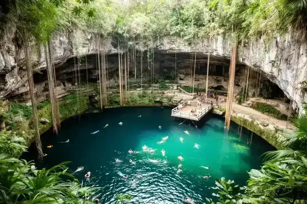
Cenote Ik Kil
One of Mexico's most famous swimming cenotes, located just minutes from the Chichen Itza entrance.
Cenote Suytun
An underground cenote near Valladolid with a dramatic light beam and stone platform—one of the most photographed cenotes in the Yucatan.
Merida
The cultural capital of the Yucatan Peninsula — a colonial city with museums, markets, and the closest major city to Chichen Itza.
Tulum
Clifftop Maya ruins overlooking the Caribbean, cenotes within cycling distance, and the Sian Ka'an Biosphere Reserve 15 km south. The southern anchor of the Riviera Maya.
Akumal
35 km south of Playa del Carmen — a protected bay where wild green sea turtles feed year-round in 2–4 meters of clear Caribbean water.
Sian Ka'an Biosphere Reserve
UNESCO World Heritage Site at the southern end of the corridor — Mayan canals, dolphins, manatees, and 330+ bird species in one of Mexico's largest protected areas.
Coba
A jungle Maya pyramid site 45 minutes from Tulum — the last major climbable pyramid in Mexico, with views over the forest canopy from 42 meters up.
Chichen Itza Tours from the Riviera Maya
Guided day trips to Chichen Itza are available with pickup from hotels and resorts throughout the Riviera Maya corridor. Tours typically include transportation, entrance fees, a certified guide, and stops at cenotes or Valladolid. If you're planning a visit during your Riviera Maya stay, comparing options early helps secure availability—especially during the December–April peak season.
Key Takeaways
- The Riviera Maya is a 160-km Caribbean coastal corridor in Quintana Roo, stretching from Cancun to Tulum.
- Major towns include Cancun (airport hub), Playa del Carmen (walkable center), and Tulum (ruins and eco-tourism).
- The region offers beaches, cenotes, Maya ruins, eco-parks, and access to the Mesoamerican Barrier Reef.
- Chichen Itza is accessible as a day trip from anywhere along the coast (about 2 to 2 hours 20 minutes depending on departure point).
- Dry season (December–April) is peak tourism; shoulder months offer better value with good weather.
- Cancun International Airport (CUN) serves the entire corridor with direct flights from major international hubs.
Riviera Maya to Chichen Itza: Route Map
See the journey from Riviera Maya to the archaeological site
Loading map…
Recommended Tours for Riviera Maya Visitors
Helpful Next Steps for Riviera Maya
Choose the next step that matches how you want to experience Riviera Maya, from a private guided tour to nearby stops or the wider area.
Tours From Riviera Maya
Best starting point for Chichen Itza day-trip planning across the Riviera Maya corridor.
View detailsHow to Get to Chichen Itza
Compare transport routes and practical planning options for the peninsula.
View detailsPrivate Chichen Itza Tour
A flexible option if you are coordinating pickup across Riviera Maya hotels.
View details